🕰️ The Sanborn Fire Insurance Map Time Machine
🕰️ The Sanborn Fire Insurance Map Time Machine
(and why the little “Key” box is the key to unlocking your town’s past)
Sanborn Fire Insurance maps are basically time travel on a sheet of paper. One glance and you’re back on Main Street a century ago—Fire Stations, Dr Offices, Storefronts, Houses and even see what buildings were made of. And the secret decoder ring? That tiny “KEY” box printed on the map. Learn a few symbols and suddenly the whole sheet talks.
Click Here To Find Your Hometown!

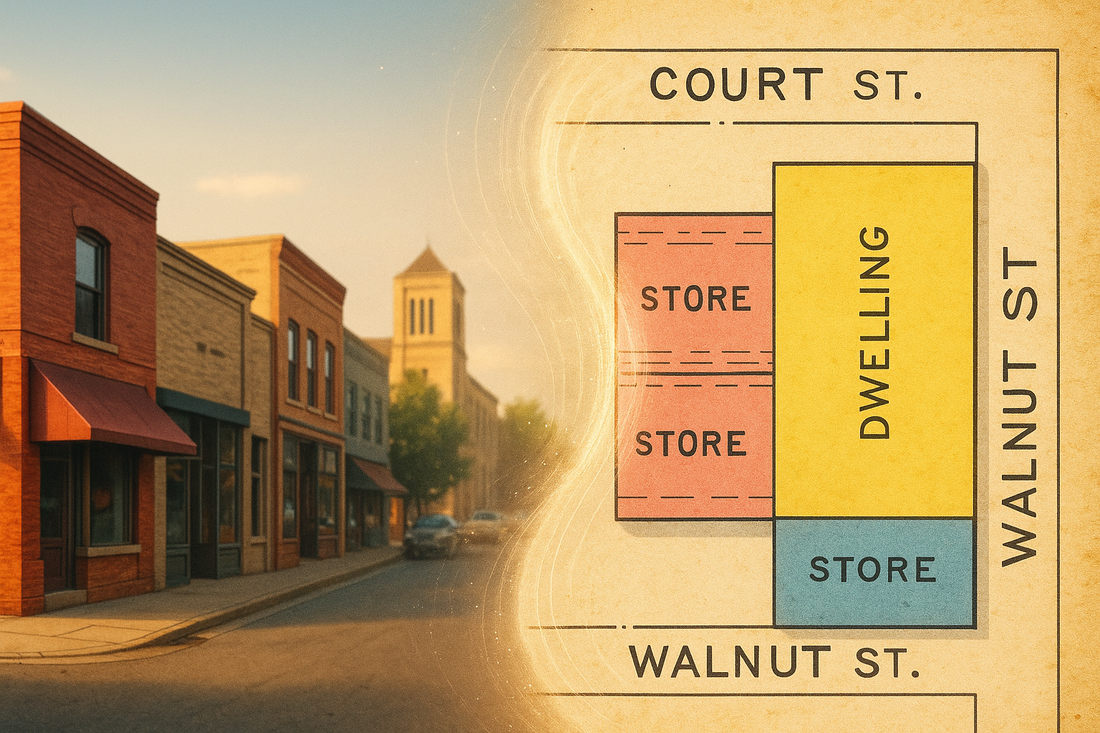
🔑 Read the key, unlock the map
Colors (super fast):
- 🟨 Yellow = wood frame (most houses)
- 🟥 Red = brick (downtown shops, sturdier buildings)
-
🟦 Blue = stone (churches, banks, public buildings)
(Legends vary a bit by year/city, but these three carry you far.)
The small “X” on a roof
- An small X in the corner of a building usually means shingle roof.
- You might also see other roof marks (small circles/notes) for composition or slate/tin—the legend spells it out for that edition.
The numbers (the ones everyone asks about)
- Big number inside the footprint = number of stories (e.g., 1, 2, 2½).
- Numbers along the walls = dimensions in feet (often width × depth, like 25 × 60).
- Small curbside numbers = street addresses.
- Lot/block numbers float in open parcel space and tie back to plats (not the building itself).
A few quick labels you’ll spot a lot
- D.= Dwelling (a house)
- Gen'l = General store or shop
- Ven'd = Veneered building (wood structure but brick or stone front for looks!)
- Vac. = Vacant (at the time)
- DG = Dry goods (another store but usually for textiles or non perishable things)
- BL SM = Black Smith
- Mill'y = Millinery (I bet you didn't think that was a women's hat store, but it it is!)
And what’s a “livery”? (All those buildings with a big "X" thru them)
A livery or livery stable was the 1890s version of a car lot + parking garage + rideshare hub. You could board a horse, rent a horse/buggy, get animals fed/shod, and sometimes hire a driver. On Sanborn Maps it’s a great clue to where the town’s traffic (pre-car!) clustered.


🔍 Why Sanborn beats state/county maps for the close-up
State and county maps are awesome for big-picture context—roads, rivers, town locations.
Sanborn's zoom all the way in to YOUR block: building footprints, materials, story counts, addresses, and business uses. If you want to find your house or family shop, Sanborn is the microscope.
🗺️ How to use your one-sheet time machine
We display one representative sheet per town so it’s clean and frame-ready. Start with street names and corner shapes. Match your building’s outline and the color (wood/brick/stone). Boom—you’ve found your house or maybe the old family shop.
Need a specific street or landmark? Many towns have multiple sheets. We show only one to keep things tidy—email us with the town + location and we’ll help you find the exact page.

❤️ Why people love these
They look awesome framed, sure. But they also tell little stories: who built in wood vs. brick, where businesses clustered, how a rail line shaped the neighborhood. It’s history you can point to—“this was our block,” “that was Grandpa’s shop.”
➡️ Ready to time-travel?
Search your town, pick a year, and see what was standing where your life happens now. If you spot something fun—an old hotel, a long-gone depot, or your great-grandparents’ place—send us a note. Thanks for preserving the past, one map at a time with us!
Click Here To Find Your Hometown!
