-
Bainbridge, N.Y. (1889)
Regular price $29.95 USDRegular priceUnit price per$39.95 USDSale price $29.95 USDSale -
Amsterdam & Port Jackson, N.Y. (1881)
Regular price $29.95 USDRegular priceUnit price per$39.95 USDSale price $29.95 USDSale -
Bird's-eye view of Antwerp, N.Y. (1888)
Regular price $29.95 USDRegular priceUnit price per$39.95 USDSale price $29.95 USDSale -
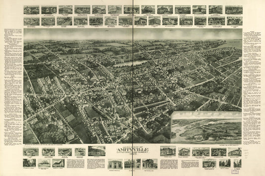
Aero-view of Amityville, Suffolk County, Long Island, N.Y. 1925. (1925)
Regular price $29.95 USDRegular priceUnit price per$39.95 USDSale price $29.95 USDSale -
View of Albion, N.Y., 1880 (1880)
Regular price $29.95 USDRegular priceUnit price per$39.95 USDSale price $29.95 USDSale -
Altamont, N.Y. (1890)
Regular price $29.95 USDRegular priceUnit price per$39.95 USDSale price $29.95 USDSale -
Altamont, N.Y. (1889)
Regular price $29.95 USDRegular priceUnit price per$39.95 USDSale price $29.95 USDSale -
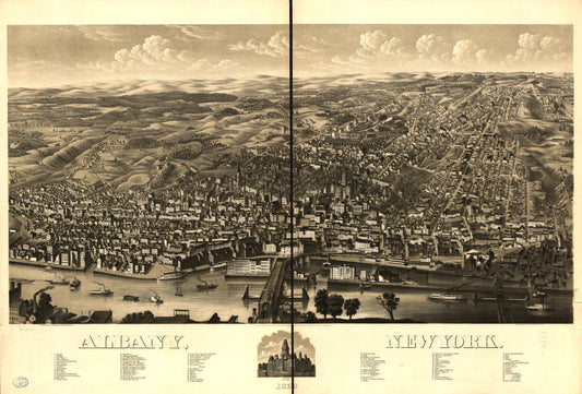
Albany, New York 1879. (1879)
Regular price $29.95 USDRegular priceUnit price per$39.95 USDSale price $29.95 USDSale