Collection: Wisconsin Map Collection
Explore historic Sanborn Fire Insurance Maps and vintage map prints from towns and cities across Wisconsin. These detailed fire-insurance maps from the late 1800s and early 1900s capture Wisconsin’s lumber towns, railroad hubs, lake communities, mill villages, and growing cities exactly as they appeared over a century ago. From early Milwaukee neighborhoods to small paper-mill towns — and even Baraboo, once home to the famous Barnum & Bailey Circus winter quarters — these maps offer a fascinating historic look at Wisconsin’s past.
Perfect for wall décor, genealogy research, classroom displays, Wisconsin history collections, or meaningful vintage artwork from your own hometown.
Browse Wisconsin by County
Explore historic Sanborn Fire Insurance map prints from all Wisconsin counties. Click a county to view available town maps and vintage map reprints.
-
Bird's eye view of the city of Beaver Dam, Dodge Co., Wisconsin 1867. (1867)
Regular price $29.95 USDRegular priceUnit price / per$39.95 USDSale price $29.95 USDSale -
Bird's eye view of Bayfield, Wis., county seat of Bayfield County 1886. (1886)
Regular price $29.95 USDRegular priceUnit price / per$39.95 USDSale price $29.95 USDSale -
Ashland, Lake Superior, Wis. 1890. (1890)
Regular price $29.95 USDRegular priceUnit price / per$39.95 USDSale price $29.95 USDSale -
A bird's eye view of the city of Ashland, Wis., county seat of Ashland County 1886. (1886)
Regular price $29.95 USDRegular priceUnit price / per$39.95 USDSale price $29.95 USDSale -
Appleton, Outagamie County, Wisconsin 1867. (1867)
Regular price $29.95 USDRegular priceUnit price / per$39.95 USDSale price $29.95 USDSale -
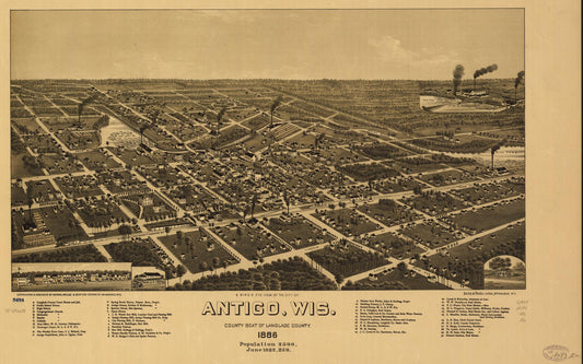
A bird's eye view of the city of Antigo, Wis. county seat of Langlade County 1886. (1886)
Regular price $29.95 USDRegular priceUnit price / per$39.95 USDSale price $29.95 USDSale