-
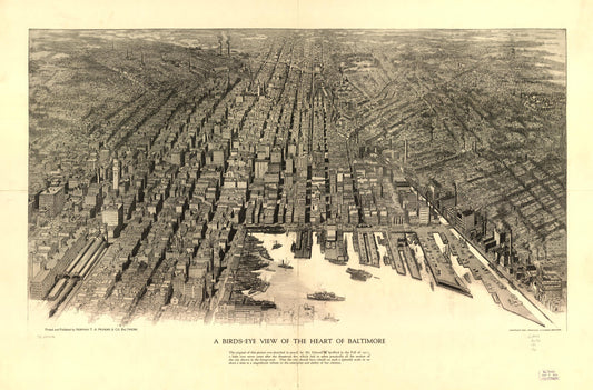
A birds-eye view of the heart of Baltimore. (1912)
Regular price $29.95 USDRegular priceUnit price per$39.95 USDSale price $29.95 USDSale -
Birds eye view of Chestertown, Kent Co., Maryland 1907. (1907)
Regular price $29.95 USDRegular priceUnit price per$39.95 USDSale price $29.95 USDSale -
Birds eye view of Chestertown, Kent Co., Maryland 1907. (1907)
Regular price $29.95 USDRegular priceUnit price per$39.95 USDSale price $29.95 USDSale -
Bird's eye view of Cumberland, Maryland 1906. (1906)
Regular price $29.95 USDRegular priceUnit price per$39.95 USDSale price $29.95 USDSale -
View of Elkton, Maryland 1907. (1907)
Regular price $29.95 USDRegular priceUnit price per$39.95 USDSale price $29.95 USDSale -
View of Elkton, Maryland. (1907)
Regular price $29.95 USDRegular priceUnit price per$39.95 USDSale price $29.95 USDSale -
View of Frostburg, Maryland 1905 (1905)
Regular price $29.95 USDRegular priceUnit price per$39.95 USDSale price $29.95 USDSale -
Birds eye view of Havre de Grace, Maryland 1907. (1907)
Regular price $29.95 USDRegular priceUnit price per$39.95 USDSale price $29.95 USDSale -
Lonaconing, Maryland (1905)
Regular price $29.95 USDRegular priceUnit price per$39.95 USDSale price $29.95 USDSale -
Midland, Maryland (1905)
Regular price $29.95 USDRegular priceUnit price per$39.95 USDSale price $29.95 USDSale -
Birds eye view of Mountain Lake Park, Garrett Co., Maryland 1906. (1906)
Regular price $29.95 USDRegular priceUnit price per$39.95 USDSale price $29.95 USDSale -
Bird's eye view of Oakland, Maryland 1906. (1906)
Regular price $29.95 USDRegular priceUnit price per$39.95 USDSale price $29.95 USDSale